Semiotics, semiotic studies, or semiology is the study of signs and symbols, both individually and grouped into sign systems. It includes the study of how meaning is constructed and understood.
In semiotics, a
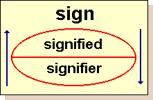
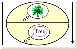
sign is defined as, "...something that stands for something else, to someone in some capacity." (Marcel Danesi and Paul Perron, "Analyzing Cultures".) It may be understood as a discrete unit of meaning, and includes words, images, gestures, scents, tastes, textures, sounds — essentially all of the ways in which information can be communicated as a message by any sentient, reasoning mind to another.
-Daniel Chandler, "Semiotics for Beginners,"
http://www.aber.ac.uk/media/Documents/S4B/sem02.htmlData Maps: Edward TufteTufte's writing is important in such fields as information design and visual literacy, which deal with the visual communication of information. He coined the term "chartjunk" to refer to useless, non-informative, or information-obscuring elements of quantitative information displays. Tufte uses the term data-ink ratio and argues strongly against the inclusion of any non-informative decoration in visual presentations of quantitative information and claims that ink should only be used to convey significant data and aid in its interpretation.
-http://en.wikipedia.org/wiki/Edward_Tufte
To download the Tufte maps handout
click here.
Psychogeography: Guy DebordSituationist Guy Debord devised the notion of psychogeography in the 1950s. It deals with the study of the exact laws and specific effects of our geographic environment. Psychogeography describes the sudden change in atmosphere a few meters further along a street, and the different characteristics of city districts. It reveals the path of least resistance a person subconsciously takes when wandering aimlessly and points out the attraction or repulsion of particular places.
Imagine if you were walking in an unfamiliar area of town and suddenly you realized that it was very dark and the shadows looked distinctly unfriendly. But what if you had a map, a map that clearly marked out entire sections of the city as safe, or peaceful or even scary. Such a map would be dramatically different from normal maps, in that the data being presented is no longer merely objective, but also subjective. Welcome to the new world of psychogeography.
Psychogeography is an umbrella term used to refer to a number of different ways to explore cities and towns. This new field is still emerging and like any new genre there is still a sense of uncertainty. Most definitions hover around the issues of maps and people’s responses to urban spaces and surroundings. The most accessible one is as follows: Psychogeography is the hidden landscape of atmospheres, histories, actions and characters which charge environments. But there is a basic thread running through all the various versions of psychogeography, and that is the generation of maps. These are maps that challenge all preconceived notions about maps.
Psychogeographic maps present maps that may or may not be objective. A case in point is 'mental mapping'. These are maps generated by individuals walking along areas in the city and recording emotions. The resulting map is more than a physical record of distances travelled, it is also a record of the internal state of mind of the map maker.
Other kinds of mental maps include maps made from memory alone. Some maps even overlay several such mental maps and the final result is a unique perspective of hitherto familiar areas. The newness of this field also leads to widely differing methods of map making. By far the most commonly used method is something known as "Generative algorithms". This involves the establishing of a predetermined method of walking, and the psychogeographers follow such algorithms in order to explore the city in new ways. Typically, the rules for walking would involve just a series of instructions such as turn right, and then the second left, etc etc, and soon the participants would end up in places they would never have consciously chosen to go to.
Another example of this new way of walking is using a map of, say, City A, and follow it in City B. Or by randomly following a person on the street and observing the route he/ she takes. While these projects seem to push the boundaries of maps further, one is tempted to ask what use is it all? For this we have to wait and see. But for sure, the city will no longer be something that lies in-between their houses and offices, instead there is likely to be a renewed interest in the concept of being an urban dweller.
-Dinesh RaoArtists's Mapping ProjectsMona HatoumMap, 1999, glass marblesMap, 1998, glass marbles (Basel)Precariously balanced, fragile yet potentially dangerous, Hatoum's work powerfully suggests the contingency that defines the geo-political landscape.
Mona Hatoum: "...the map was very fragile: as soon as one set foot on the parquet, the marbles on the floor started moving. At the same time, the work was very menacing. I like it when things are attractive and forbidding at the same time; both seductive and dangerous. The marbles made the floor hazardous, because you could slip on the glass balls and fall down. I've done quite a few works which destabilize the ground you walk on."
Hot Spot, 2006, stainless steel and neon tubeHot Spot interrogates the notions of ‘boundaries’ through the depiction of a world map – an ongoing theme in the artist’s work. Hot Spot is a cage-like globe, approximately the size of a person’s height and arm span, which tilts at the same angle as the earth. Using delicate neon to outline the contours of the world on its surface, the work buzzes with an intense energy, bathing its surroundings in a luminescent red glow. Compelling and seemingly dangerous, Hot Spot suggests that it is not simply contested border zones that are political hot spots but an entire global situation: what Hatoum describes as a ‘world continually caught up in conflict and unrest’.
Brian CollierHuman Movement Patterns, 2002"Tracking an individual's regular movements can be both uncomfortably intimate and frigidly anonymous. For this project I create a series of map-portraits based on several individual's habitual weekly travels. The appearance of scientific objectivity in the finished map-portraits works in direct opposition to the fact that I personally know all the individuals represented. Furthermore, the initial maps were made by those individuals themselves, rather than an outside observer. Most of the participants reported that this self-surveillance was slightly disturbing. There is an underlying intimacy, evoked only subtly, when the viewer notices the flesh-like quality of the hand-waxed paper or the use of only first names of participants."


